Ask Western Canadian gold panners what is the best public panning spot and I wager most would say Tranquille River. It may even be unanimous. It’s what I would say.
Okay, that’s not entirely true. It’s what I would have said three summers ago. Now, I’m not so sure. Like all good things, salmon ends them. Yeah, you read that right. Allow me to explain.

The Tranquille River public panning area, a name I just made up, isn’t an official panning reserve. By that I mean it’s not government sanctioned like the fourteen public panning reserves that British Columbia has designated across the province. Hence my made-up name.
In addition to those fourteen panning reserves, in BC you are allowed to hand pan in any stream not in an active claim, not on private property (unless given owner permission), not on a First Nation reserve, and not in a heritage site/protected area/park.
There are exceptions, of course. Mission Creek, for example, is a well-known public panning area in Kelowna that resides within a regional park. And the portion of Tranquille River open to public gold panning is within a protected area. Yeah, I don’t understand it either.
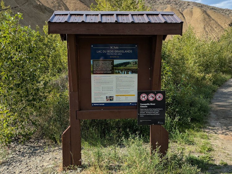
The Lac Du Bois Grasslands Protected Area is located north of Kamloops. With 16,000 hectares of rolling foothills, forests, and small lakes it offers hiking, mountain-biking, wildlife-viewing, fishing, and hunting. And in its western end, Lac Du Bois is home to approximately 9 km of unclaimed, and unclaimable, Tranquille River waterway.
Until recently, this was arguably the best public gold panning area in BC, particularly the stretch of river from the bridge to the water diversion dam. It was popular, and more importantly, productive. Unlike other panning reserves, Tranquille River coughed up more than just flour gold or small flakes. Larger flakes and even pickers were possible.
Our first time in the summer of 2023 produced one such picker. When I found it in my pan, I really didn’t believe it was gold. But it was. My son, with his more youthful eyes, confirmed it. It included quartz, mind you, but a genuine picker, nonetheless. How exciting!


So exciting, in fact, that we’ve returned to Kamloops three times since then in hopes of adding to our modest collection of gold. It was on the second of these return trips that we learned, quite accidentally, that things have changed.
That second visit happened during Spring Break in the hope of catching the river at its lowest flow, thereby exposing additional fertile panning grounds. However, when we arrived at the trailhead parking lot, we were greeted by a sign explaining that Tranquille River was closed to all recreational activities, including gold panning.
I learned three things that afternoon. First, always check the Lac Du Bois Grasslands Protected Area official website for potential river closures. Second, our planned summer trip to again pan in Kamloops was in jeopardy. And third, the reason for it all was … salmon.
Restriction of Activity on the Tranquille River
The Tranquille River flows into the Thompson River, itself the largest tributary of the mighty Fraser River. The Fraser is the largest salmon-bearing river in Canada with the Thompson and its tributaries hosting some of the largest Pacific salmon runs on the continent.
According to the official Lac Du Bois website, the Tranquille has seen a “re-emergence” in spawning by the threatened interior Fraser Coho salmon. The new recreation restrictions as BC Parks and various agencies endeavor to protect this re-emergent spawning activity and “determine which recreational activities are appropriate.”

Initially the restriction covered the entirety of the Tranquille River within the protected area. This resulted in pushback from the community, including gold panners who were loath to lose access to a rewarding public panning area.
The pushback did result in a change, at least for time-being. While the two kilometres of Tranquille River from the bridge to the water diversion dam remains off-limits, recreational activity is once again allowed upstream of the dam. For the time-being. Sorry, but that needs repeating as it could change at any time.
On the bright side, this updated restriction meant our planned summer visit could proceed as planned. But on the dark side, we would still be forbidden from panning in the part of the river that coughed up my precious picker. But on the slightly less bright side, that still left seven kilometres of Tranquille River to explore.
Below is my account of our adventure above the water diversion dam during the summer of 2025. As you’ll learn, there is gold to be found in the publicly accessible part of the Tranquille River within the Lac Du Bois Grasslands Protected Area. Whether it’s the best public panning area in BC, well, I’ll leave that for you to decide.
Panning Below the Water Diversion Dam
I’ll start by discussing the area below the dam. Hey, you never know, it may reopen in the future. Besides, you hike right past it all to get to the water diversion dam and the public space beyond.
The easiest way to access the lower Tranquille River is to follow Tranquille Road west of Kamloops, past the airport and golf course. You’ll then pass a couple of trailheads before the road splits; gravel to the south and paved to the north. Continue along the paved portion, which veers to the north, and across the railway tracks.
Past the tracks, the road turns to rough gravel and is now named Tranquille-Criss Creek Road. It winds its way for 1.3 kilometers, passing a small gravel pit, at which point you’ll want to turn to the right into a very rough driveway of sorts. This is the access to the parking lot and trailhead you use to hike into the Lac Du Bois Grasslands Protected Area. If you cross the bridge over the river, you have gone too far.
Be careful when accessing the parking lot. The “driveway” is in very poor condition and at one point there’s a broad low spot that has abrupt sides and is often flooded. If you have a car or even a modest SUV, you could bottom out traversing this spot too quickly, so take your time.

The parking lot itself is just a wide, gravel area with little in the way of trees for shade or fencing for confinement. In the hot, summer sun even the best cooler will be taxed trying to keep contents cool if left in your vehicle. Valuables may also be at risk.
At the north end of the parking lot is the trailhead for the two kilometre hike along the east side of Tranquille River that takes you to the water diversion dam. There is a barrier to prevent vehicles from driving on the trail and signage which will tell you that you can’t have fun below the dam. And the boot scraper, which I’m not sure anyone uses, gives some credence to this being a “protected area”.


Much of the trail is basically a gravel road. It’s certainly wide enough for vehicles and there is even a Texas gate along the way. It transitions from partially treed to open sagebrush and back with the width of the valley oscillating as well.


It’s an easy trail in the sense that there is very little elevation gain for most of its length. However, it does have flooded sections due to leaking water diversion infrastructure and beaver activity. And I’m not talking little puddles to hop over. There are sections multiple metres long that require skillful navigation along the elevated trail edges or stepping across logs and stumps folks have emplaced to avoid soaking your feet. This can be a bit of a pain in the ass if you’re packing in a load of panning gear.


Gold panning used to occur along this entire section of the trail. You’ll see several dirt paths through the shrubs and trees from the main trail to the river. Others use this area for recreation as well, be it rockhounders, dog walkers, and parents with kids hoping to cool off in the water. And there are those who simply enjoy a stroll or ride on the trail.

A word of warning regarding this trail. Prepare for mosquitoes! All the standing, or slowly flowing, water is ideal breading ground for millions of mosquitoes. They’re not around all the time. Our first two visits were almost void of mosquitoes. But, oh lordy, on our most recent trip they were out in full force to make up for their prior neglect. Bring bug spray, the potent type, and use it, lest you find yourself riddled with welts!
Approximately one kilometre in, you’ll come upon an abandoned day use area. It’s called Pine Park on Google Maps and appears not to have been maintained in many years. Comprised of a derelict bathroom structure and a picnic shelter beneath several large cottonwoods, this fenced-off area might have been quite nice at one time. It’s a shame it’s been let go like this.


Pine Park was a popular spot for gold panning. Cut through the park to the river and you’ll see evidence of panning everywhere along the exposed riverbed and in the riverbanks. This is where I found my picker on our first visit and on subsequent returns, we’ve always found gold here.


Continuing north of Pine Park, the trail narrows some, as does the river valley. Additional access points to the river are visible all the way to the water diversion dam and at their terminus further evidence of panners hunting for gold.
Panning Above the Water Diversion Dam

Once you reach the dam, the trail pretty much comes to an end. There’s a final dirt path down to the river and evidence of a “road” heading off into the scraggly woods, but for our purposes the trail stops here.
Like Pine Park, the water diversion dam looks to have peaked many decades ago. It still functions as a dam, though without any reservoir being formed behind it. Water is diverted from the main Tranquille River course but overall, the structure screams “abandoned”.


Upstream of this infrastructure is where gold panning and other recreational activities in the river, are still allowed. For the time being.
I had high hopes for gold panning in the stretch immediately above the dam. I don’t know what the source of the gold on the Tranquille River is, but if flood gold plays any role, I was certain the area right above the dam would be rife with it. Twice now we’ve tried and both times we’ve been disappointed. Not empty-vialed, by any means, but compared to the relative bounty below the dam, the amount of gold was disappointing. I’m not sure why.
Once outside the Lac Du Bois Grasslands Protected Area to the north both the Tranquille River and Watching Creek are fully claimed, presumably because there is gold present in both waterways. We’ve also found gold further to the north of the dam, though none of that was particularly large prolific or large either. What makes the stretch of river below the dam so bountiful is a curiosity that I’d love to learn more about.
That said, there is plenty of river north of the water diversion dam that we haven’t explored. Roughly seven kilometres of it before those claims kick in and panning is off-limits to the public. We’ve just scratched the surface in our two attempts, venturing only a few hundred metres north of the dam at best.

Our first attempt doing this took us to some large, gravelly outcrops that are eroding into the river. I believe these distinctive deposits are glacial in origin (or age, at least) and I had hoped they might be the source of the gold, but we found nothing.
The second time we did find a couple small flecks of gold in the exposed riverbed around that final pathway to the water. It was underwhelming and by comparison with what’s present blow the dam, a disappointment.


Perhaps things improve further up the river valley. Without a trail, though, going further requires either wading up the river itself or bushwacking through the thickets. We were not equipped for the former and unwilling to do the latter.
The West Side of Tranquille River
Instead, we chose an “easier” path to exploring the upper reaches the Tranquille River within the protected area. On consecutive days, we drove up the west side of the river on Criss Creek Road and hiked down to the river at two locations: the Slot Canyons and Watching Creek Campground.
Both these locations are shown on Google maps and looked like ideal spots to access the river for panning. If there was no gold, well, at least we’d enjoy beautiful scenery for our troubles. The Slot Canyons, in particular, sounded like a cool thing to see all on their own, so I was keen to check them out.
What I failed to account for, once again, was elevation. God, I’m horrible for this when planning BC adventures. Criss Creek Road is a gravel forestry road that, while roughly following the west side of the Tranquille River, does so by climbing up onto the hilltops overlooking the valley.
Unlike the trail discussed above which is essentially in the floodplain, Criss Creek takes you up to the peaks and requires you to hike back down into the valley, with very little in the way of proper trails.
The Slot Canyons of the Tranquille River

Nowhere was this unanticipated reality starker than at the Slot Canyons. I damn near died. Twice. Once going down and once coming up. Worth it, oh yes, but trust me, be prepared for significant energy expenditure. Oof!
The Slot Canyons trailhead is roughly 7.5 km from the bridge that I warned you not to cross above. This time you do want to drive across the bridge and follow the road up to a small pullout on the right-hand side.

Parking is limited with only room for perhaps half a dozen vehicles at most. When we arrived, there was even someone in an old, beater motorhome camping in the pullout.
Getting to the river is quite an adventure. There is little resembling a proper trail here. You’ll find pathways weathered into the mountainside and dirt trails through meadow and forest but don’t expect consistent grades or switchbacks. People with health or mobility issues will not be able to do this hike.


Along the way, you’ll encounter destroyed vehicles that have been intentionally driven off the road and plunged into the valley. On one hand, this wanton destruction is kind of fascinating. On the other, it’s a damn shame this junk is left here in a protected wilderness area.
I’m sure the cost to remove is excessive, with no assurance it won’t happen again, but it does distract from the gorgeous wilderness all around. The views from the trailhead and through the early portion of the descent are wonderful. This is a hike worth doing even without gold panning intent.


The distance as the crow flies from trailhead to river is under 500 m. The twists and turns and ups and downs required to get you from A to B, however, increase hiking time substantially. Bring everything you need for the day with you because scooting back to your car isn’t in the cards. Unless you’re a masochist.
One saving grace was a noticeable lack of mosquitoes. We had been swarmed by the bastards just the day before south of the dam, but up here, both along the trail and at the river, we were rarely, if ever, bothered by them. I can assure you, scurrying out of the Slot Canyons while being eaten alive like we did from the water diversion dam would have been a hell worthy of amending the Geneva Convention.
The trail ultimately brings you to a short (~100 m) stretch of the Tranquille River between two slot canyons. The most striking thing about this piece of real estate from a gold panners perspective is the presence of exposed bedrock. While there are many boulders, including a huge one, and the same riverbank till seen below the dam, the bedrock was exciting to see.
We spent most of our time panning the area immediately north of the downstream slot canyon. There was evidence others had panned here including a huge hole in the hillside a bit back along the trail. Finding gold, however, was hit or miss.


There are thicker deposits of coarse sand with plentiful black sand that produced some small flakes. Never more than one or two in a pan, though. And the consistency of these flakes was erratic. I didn’t find much digging into the riverbank. Some boulders relinquished a flake or two, but others were barren.
My son, however, found a bit of a honey hole along a three foot long by one foot wide bedrock trench filled with sand and fine gravel. Every pan produced multiple flakes, some bigger than average, from both the overburden in the trench and trapped in the dipping slate bedrock.


Sadly, however, other similar trenches in the bedrock were not nearly as prolific and often barren. What made that trench, and only that trench, so rewarding is another curiosity. More so, I’m dying to know if it reloads with each spring flood or did we just happen to stumble upon it before anyone else?


Upstream from our little hunting ground is an abandoned channel that diverges from the main channel after it exits the upper slot canyon. This abandoned channel likely floods each spring so again I had high hopes there might be gold easily accessible around its boulders. That was not case. Oh, I recovered a couple little flecks but the baby rattlesnake sunning on a rock and a lost crevasse scraper were more the more interesting finds.
Also of interest was the platinum we thought we had found. When placed in our snuffer bottles it proceeded to paint all our gold silver. Turns out it was not platinum but mercury amalgam, something we’d not yet encountered in our brief panning careers.
As for the Slot Canyons, they were very cool to just look at. Without hip-waders or a bathing suit, we didn’t want to wander into them via the river. Others do and I’m sure it’s a popular escape in the hot summer.


In fact, while we were gold panning a man and two women showed up looking to do just that. More to the point, I think the man was expecting to do more than just wade into the water and secret hideaways of the Slot Canyons. There was a distinct look of angst when he realized a man and his son had invaded his “lucky” swimming hole. Sorry, buddy.
Watching Creek Campground
Next, we ventured further along Criss Creek Road to the Watching Creek campground. How much of a campground this was at its peak is unknown to me, but it surely wasn’t more than a rustic, forestry style campground with zero services and supervision. Even finding it can be a bit tricky as there is no longer any signage or much evidence it ever existed from the road.
Roughly 4 kilometres from the Slot Canyons pullout there is a road into the forest on the right that takes you to what was once the Watching Creek camping area. This road is very rough and unmaintained. There are ruts and muddy spots and eventually it becomes unpassable. You can make out former campsites and we decided to park in one of these and hike the remainder of the way for fear of getting stuck.
Following the campground road, we exited the trees into a clearing that looks to have been a loop at one time. A single tent was set up in this loop so some folks are still using it for camping.

At the east end of the loop we found a solitary metal sign indicating a trailhead. We followed it down the steep hillside to the river, another not-so-simple descent and eventual ascent. While not as taxing as the hike to the Slot Canyons, the elevation change here is still substantial. It won’t go well for those with limitations. Or flip flops.


Beside the river, in another small clearing, there was a stone firepit with recently chopped wood again indicating that this camping area is being used. There are additional dirt trails meandering through the woods and possibly heading all the way south to the Slot Canyons. We did not explore them preferring to get busy panning.

The Tranquille River is a bit wider here but otherwise very reminiscent of the stretch below the water diversion dam. The scenery is lovely and aside from the odd hiker or perhaps a camper, we were alone with Nature. I liked it very much. It’s a beautiful place to spend the day gold panning. Even the mosquitoes left us alone.


There is gold here, too. Not surprising considering the claims begin just a short distance north of here (Do NOT pan upstream of where Watching Creek enters Tranquille … that land is all claimed). We only found flakes, most of them small, pickers or nuggets avoiding us once more.


Somewhat ironically, our best results were from the riverbank deposits. This was the opposite of our experience at the Slot Canyons. Evidence of other panners was prevalent and one large, already present excavation into the bank proved most successful for us as well. I explored a bit on both sides of the river but had limited success. With more time I’m sure additional sweet spots could be found.

In Conclusion
I will never portray myself as an expert in these matters. Our experience with gold panning on the Tranquille River is limited to just three visits. Nonetheless, here is what I have learned from those three successful trips.
There is gold all along the Tranquille River. The best of it seems to occur below the water diversion dam, which is unfortunate since that stretch of river is now off limits to recreational activities of any kind.
The Slot Canyons are cool geological features and alone are worth the excruciating hike down. Gold is spotty in the immediate area, though one bedrock trench did produce an exciting succession of multi-flake pans.
Watching Creek is easier to get to than Slot Canyons. There the riverbanks seem more productive than the riverbed, which is the opposite of what we experienced at Slot Canyons. For ease of access and runway to explore, I’d chose Watching Creek over Slot Canyons for panning.
All that being said, we haven’t come close to exploring the full length of the Tranquille River within Lac Du Bois Grasslands Protected Area. There undoubtedly is gold all along its course and perhaps there are some honey holes still waiting to be discovered.
In my humble opinion, with the closure of the stretch below the water diversion dam, Tranquille River is no longer the best public gold panning area in BC. That’s a shame because our first time there was so much fun. And I don’t even like salmon.